 OpenGeofiction

I have redeveloped Marvin’s main area with the towers and I want to know your feedback! This is but the first step in developing the nation of Oketia. I want to make it simple and easy to navigate but with a complex history. Any Feedback? I would love to hear from both new and experienced members to see what your opinion is!
Users' Diaries
Recent diary entries
Posted by coshatiuav on 24 October 2019 in English.

Excuse me if this has been asked already - but the current northern border of Commonia and all countries above it are not shown at zoom level<4 - is it possible to fix this?
Also, will it be possible to implement (or show me if this is already a thing) a way to search for user diary entries?
My coastline was deleted, I don’t want to construct it again node by node. How do I revert it back?

Hi everyone,
I was looking at the wiki currently and I saw that most of the planes that are out there are bigger airplanes, with not many planes that have less than 150 seats.
In the real world, there are 2-3 companies that take advantage of this by manufacturing small aircraft. (Bombardier, Embraer, McDonald Douglass(I think they merged with Boeing??))
In the FSA/OGF world there are none yet.
Maybe there are some that I missed??
Another thing is that the routes that are used with these aircraft are short-haul routes, used to connect a passenger from their home airport to the closest hub the airline has to that airport. Then these passengers get on medium-haul flights or long-haul flights to their final destination.
Overall, what I am trying to say is that the OGF world needs more short-haul routes and medium-haul routes than long-haul routes. We also need new aircraft to service these routes.
If there is something that I missed or anything you want to tell me, feel free to comment on this post.

this housing block, which gets me a massive amount of edits, when I copy and paste. however , when i save , it comes up with this:

any solutions?
I just found this site and it is blowing my mind.
I’ve been working on a medium sized coastal city in Lonowai for about a month now. It contains 2 shopping malls, multiple hotels, a convention center, expressway, project buildings, a hospital, multiple strip malls and smaller stores, and a lot more to come.
Posted by HugoGamer34346 on 21 October 2019 in English.
Last updated on 22 October 2019.

Hey there, I am trying to upload my changes since yesterday from my city, but I can’t, I only can put the comment about the changes, but I can’t upload or cancel them,  almost every 5 hours disappears part of what I have already edited, it had approximately 215 modifications and now It only have 173, I don’t know what is happening, please help.
Hello, i am posting here because i have strange problems with my city name displaying after 30km away (when the cities become points).
To be exact, i put a city mark properly, but it won’t show up past the 30km range. I did it 3 weeks ago and rest of the map on the current zoom updated so it’s not zoom updates. I tried many things, such as adding capital=4 tag (because this’d be the “capital/largest city” of my state i’m mapping in), making a new city tag, W A I T I N G, removing/adding population mark in my city name, and nothing. Later, i added some planned cities that are 0% complete and are just placeholders, when i suddenly see one of them is displaying from even 100km away! What is this problem caused by, and how to fix it, if i can ask? Also, i recently noticed the city stopped appearing from 30km and only appears to 20km zooms.
If anyone needs the location, it’s here: https://opengeofiction.net/#map=13/-45.2947/140.0886 (don’t mind my poor mapping or the fact that the city is like 1% done, i just recently got this territory).

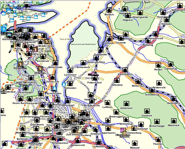
I’m proposing to change the southern end of the Firth of Hetzer, in that it will end on a line between Middel Hetzer (west) and Meldich (east). Although fully within the territory of Utterland, it is quite a change in coastline. Anybody got any objections? Have written to the owner of Shlonsk, which is only a few km north of this proposed line.
Current situation

Working on the skerry coast around Frjalshöfn, it just happened that I imported 680.000 nodes into JOSM, spreading on a total edge length of about 4.500 km. This results in 150 nodes per kilometer, which means, one edge is 6 metres long on average. Don’t worry, I deleted everything. ;-) (Just for explanation: of course, I didn’t draw this by hand. I used the “how to create realistic forsest coverage” method from the wiki and then fractalized the shapes).
For an edgy coast line like a skerry coast, what node distance would be adequate? 20 metres? 50 metres?
Just a small question. Can I, either out of JOSM or out of OGF directly (or any other way), export map data as svg file? So far, I didn’t find a solution.
Hello everyone!
I am mapping in Indahtanah, a state in Lorotoban. It is a Timor-based island nation. You can read more about it here.
With that out of the way, I was mapping rural ‘stuff’ (farmland, crops, orchards, et cetera). But, I came to a part where the farmland meets with the forest (in this case, rather hilly). I can’t find any good examples of rice paddies or any mountainous farmland in Openstreetmap. If anyone has an example, can you please comment it down? I would like some inspiration mostly in an Asian place (rice is mostly grown in Asia anyway).
Hello everyone,
i am trying to map grids for my town. it takes very long to do and wastes time. how can i map grids faster?
thank you,
DMP5
I noticed how there’s a line for a racetrack, but only non-motorsports. What should I use to make a motorsports track?
Cycleways are small infrastructure projects which makes cycling easier , for the experienced and inexperienced.I’m suprised with all the detail in some places that these have been left out. I have made a small section in Burnieside-Devonport which runs along Thnn xe s phers so.
I have realised that 1. My capital city has an unnatural shape 2. I have a bad rural-urban transition 3. My nation looks 3rd world. I put my country at 0.8 on the Global development index, but my maps don’t reflect that 4. I don’t have much land detail
So, with that said, most of my capital city will be getting deleted. However, some of the more dense shopping districts will not. Here is the plan: * Remove my Main Motorway. * Place trunk roads at intervals, in a gridlike style. * Have 1 or 2 motorways, depending on the development of other things. * Place small towns where trunk roads intersect, as well as a few other small towns scattered around. * Not every intersection will have a town, some will be larger towns or gas stations, others will be parks & tourism. * Detail the rural areas to have more areas like farmland. * Add more mountains and peaks.
Hello to the whole community, the truth is that I only come to ask for an opinion about this area of farms that I have been developing today, I don’t know much about farms but I would like to know your advice to do better
I noticed when I was going to map my FS state how there’s some flooding in Archanta, is this happening for anyone else?

Hello to the community. After finishing Fort Vondréaux a few weeks ago, I decided to continue with Vondréaux , but I’m not sure about some points of the city’s configuration. I want to keep my mapping standard as much as I can, and therefore I ask your opinions about the project (suggestions for re-mapping are accepted).
Happy mapping,
Mapping Expert