Diary Entries in Spanish

Recent diary entries

Posted by Martinawa on 9 November 2021 in Spanish (Español).

Estoy encantado de anunciar que Castellán va a empezar su andadura como proyecto colaborativo, para crear una nueva madre patria para el idioma Español (castellanés) en OGF. El debate acerca de este nuevo proyecto va a tener lugar en los foros de la wiki, mediante los cuales podéis acceder, si no lo habéis hecho todavía, mandando un mensaje privado a Alessa (Preferentemente, en inglés).

Esta es la página de la collab en la wiki, donde podréis ver un resumen del estado del territorio. Esta es la página del foro en la wiki sobre Castellán, donde podéis enviar dudas, sugerencias, o discutir sobre los temas relevantes acerca de Castellán.

Todos estáis invitados a participar de este proyecto para hacer de Castellán un lugar remarcable en el mapa de OGF.


I am excited to announce that Castellan is going to launch as a collaborative territory, with the goal of making a new motherland for the Spanish language (Castellanese) in OGF. The discussion about this newborn project will take place on the wiki forums, which you can access, if you haven’t yet, sending a private message to Alessa.

This is the wiki collab page, where you will be able to see a summary of the state of the territory. This is the wiki thread page for the Castellán collab, where you can send doubts, suggestions, or discuss about the relevant topics regarding the country.

I encourage you to participate on this project to make Castellán a remarkable place on the OGF map.

Happy Mapping, Martinawa, on behalf of all Castellán coordinators.

Location: 39.333, -3.000

Hi, guys! After a lot of struggle to get JOSM to work on my computer, it finally does. I started mapping in a blue territory and now I have my own country, so I’m going to work on it, but I mapped with the OGF editor (for the same reason that it didn’t works on my computer) and until now I will do it with JOSM and I have a big question.

The first thing I want to edit is my borders and the coastline, but I don’t know how to do it and I don’t want to ruin anything or flood the continent continent.

Could someone explain to me how those elements are edited? I didn’t find how to map that in the examples or guides

Thanks.

By the way, my country is called Costa Azul (ingerish: Azure Coast), in Tarephia.

Location: Cerro Gagarés, Los Cerros, Escar, Costa Azul
Posted by Timoteosg on 19 October 2020 in Spanish (Español). Last updated on 20 October 2020.

ATTENTION NEW USERS – AS THE WIKI MAY REMAIN INACCESSIBLE, ALL RULES AND ESSENTIAL INFORMATION ARE LISTED HERE IN THE USER BLUEBOOK!

Hello, I’d like to share a tip for you, how to have the wiki at normal speed.

First you have to go to your Preferences (stopping it after 10 seconds to load basic HTML should work), then go to Appearance, and change the Skin to Modern. Click save. Then, enjoy wiki-ing.

Thanks to TheMayor for sharing this trick with me.

Happy mapping and maybe writing, Tito_zz

Posted by sude on 2 October 2020 in Spanish (Español). Last updated on 12 October 2020.

Wiki has many troubles for the moment, so I decided to addapt the content of OGF:Ohesia to a user diary and also make you part of this project. Here I go.


Ohesia (Oǵemetézt in ohesian and Ochezien in kalmish) is a country located in northern Antarephia. It consists of a federation composed by about 8 regions (which still don’t have a name).

This country was an old kalmish colony and its linguistic situation is similar to South Africa. Kalmish is specially spoken in the capital and its surroundings, and a native language (conlang) is spoken in most of the rest of the country. The size of the country is about the size of Honduras.

Name of the country

The main idea is to create a similiar situation to real life Turkey and Turkmenistan. Ohemian language is the main language of the Antarephian family as well as turkish is of the Turkic family.

Who can map

Everybody is invited to map in this collaborative country, specially german people. Regarding the languages that will be used, there is further information down below.

Collaboration Rules

(A part of this point is copied from the OGF:Moonshine Archipelago wikipage, a nice project with similar characteristics that shows that collaboration can work)

Things you can do at anytime without asking. But be aware that concurrent editing without coordination may result in conflicts. Make sure to know how to resolve them.

  • Map new villages (pop. ~500 - 30 000) and connect them with roads
  • Extend existing villages within a reasonable amount
  • Build tertiary and secondary roads
  • Improve existing villages with buildings and details
  • Add natural features
  • Create inner borders

Things everybody wants to do, but we don’t need too many of them or we need coordination. Remember it is not a blue territory

  • Build primary roads
  • Naming major features

Things we just wont allow even if you ask us. Exceptions may still be possible in certain circumstances with a very good reason.

… See full entry

Location: -24.647, 37.562
Posted by Timoteosg on 24 September 2020 in Spanish (Español).

Presentando: Deodeca

this article is the Spanish version of the English article found here

Deodeca es un país en Arcanta del Sur, con frontera a los Estados Federados, Ardencia y Ambrosia. Va a ser un país colaborativo.

Pero necesitamos tu ayuda

Para un país realista, hice un plan para Deodeca.

  1. Decidir una lista de “colaboradores iniciales” (los pasos siguientes serán decididos por estos colaboradores iniciales).
  2. Decidir una costa nueva, después una geografía.
  3. Decidir la hidrografía (los ríos y lagos)
  4. Decidir dónde poner las ciudades, después las autopistas/autovías y los ferrocarriles.
  5. Decidir las subdivisiones (provincias, estados o similar).

Después de eso, se van a repartir estas subdivisiones como en los Estados Federales, pero no se puede añadir mas ciudades, autopistas/autovías, trenes o cambiar la geografía y hidrografía significativamente sin permiso de mí. También se va a votar sobre cosas como la bandera, los nombres de los ríos, la capital, el esquema de numeración de las rutas, etc.

Si tienes interés, enviame un mensaje o pon un comentario abajo.

Location: Wirramay, Deodeca
Posted by Timoteosg on 17 September 2020 in Spanish (Español).

Introducing: Deodeca

Deodeca is a country in Southern Archanta, bordering the Federal States, Ardencia and Ambrosia. It is planned to be a Spanish-speaking Latin American country. It will be a collaborative country.

But we need your help

The plan is the following, in order:

  1. Find a list of interested mappers, a “group of initial collaborators” (steps following are decided by that group)
  2. Rework the coastline and then make a basic topographic plan.
  3. Make a basic hydrology (=water) plan
  4. Decide the location of cities and main roads.
  5. Set the borders of subdivisions.

After that, the subdivisions (=provinces, states or similar) will be given away to users wanting it, like in the Federal States, however, they should not add more cities, and can only add motorways with the community agreeing. All collaborators, even those not initial, will just be referred to as “collaborators”, who will be able to vote on things like highway numbering schemes, river names, flags, etc. The initial collaborators will be able to vote on the first five steps and things like that.

If you’re interested, message me. Things will be organised similarly to the Federal States, however learning from the coherency issues it has/had.

Location: Wirramay, Deodeca

Hello!

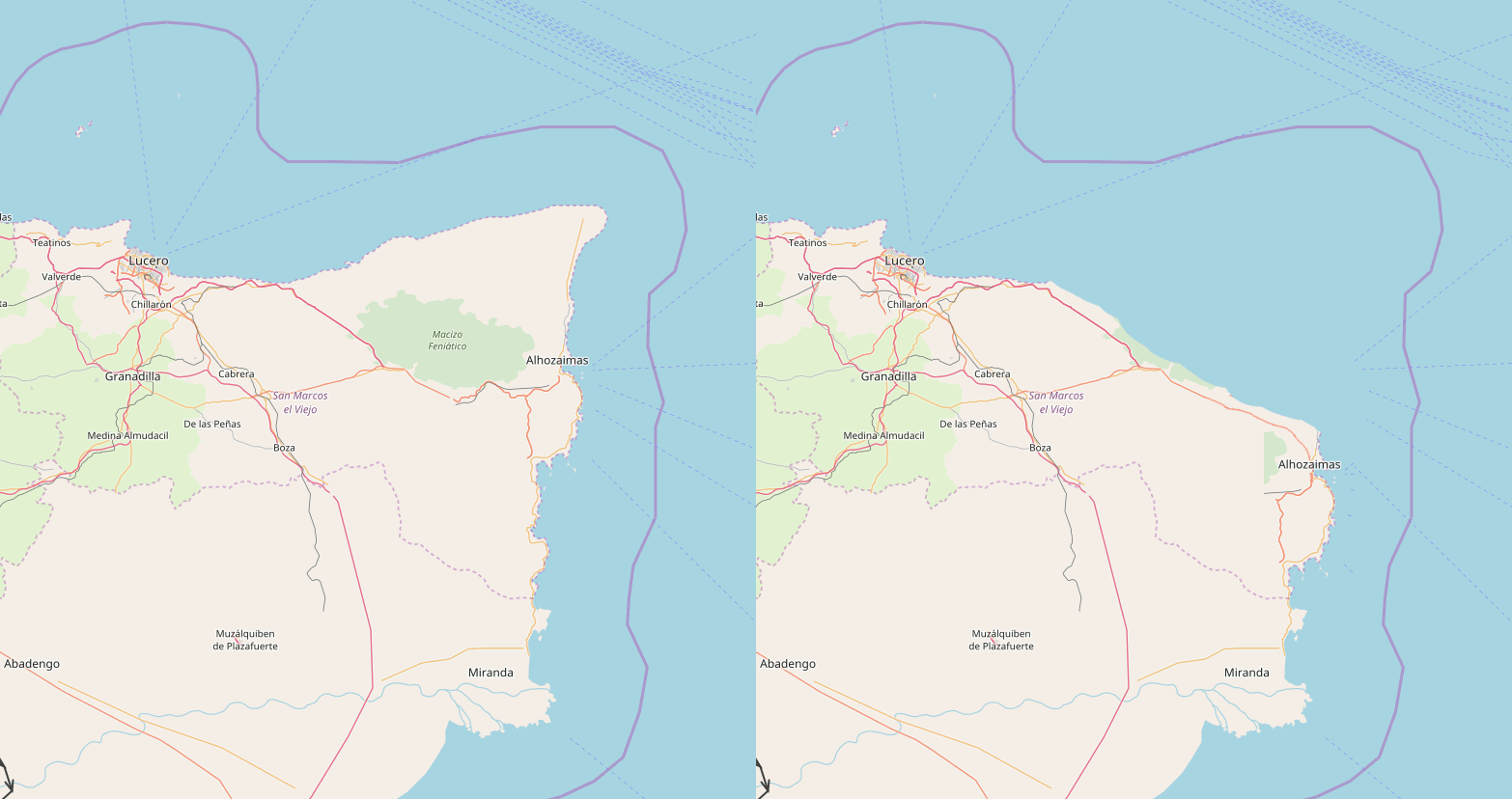
Before I moved from Commonia to my current territory, I used to name my territory “San Marcos”. When I arrived to Antarephia, I decided to continue to name my country “San Marcos”, and I placed my old mapping in the north making a region with the name of “Old San Marcos”.

This region has always theoretically been composed by 4 (5?) provinces:

  • Lucero (capital)
  • Granadilla
  • Castillejo y Ebre
  • Alhozaimas
  • Jaca (?)

Even if I tried to think about how to make it fit with the area, I wasn’t able to. So I’ve had this idea to fix it:

… See full entry

Location: Antañago, Nueva Alhozaima, San Marcos el Viejo, San Marcos
Posted by sude on 30 August 2019 in Spanish (Español).

Hello everybody

Somedays ago, i saw the map of languages in the Wiki. Honestly, I didn’t like it because it used points and it was very unaccurate. I had the idea of doing the same thing, but with relations.

It has been difficult because I had to see country by country which language people use there, extract the points of the relations and put it into the map.

I hope you like it: https://wiki.opengeofiction.net/wiki/index.php/Map_of_languages

Furthermore, I realized that there is a very common mistake in a lot of countries: mixing languages randomly. In my opinion, it’s not realistic at all. For example, I saw countries in which there are arabic, hebrew and chinese script in the same city. I think that we should follow the quote “a nation, a country”, or as least, “a country, a language”.

This is the reason why I didn’t add some countries to the map, cause I couldn’t determinate which is the main language of the country.

However, it’s a fact that there are countries where people speak several languages. That happens in the real life. So I recommend you to delimitate the border between those languagues.

That’s only my advice. You are not forced to follow it, but I ask you guys to think about it.

There are a lot of countries in which I didn’t put the language because I didn’t have time enough, so I ask you to add them.

In addition, I’m using the same colours that were used before, and I added the colour Black to rare languages that are spoken in very few countries.

Posted by Rick on 2 June 2019 in Spanish (Español). Last updated on 4 June 2019.

hola, Saludos desde México.

Quisiera saber cuál es la Ciudad más grande de OGF para visitarla y observar como esta construida, tengo un proyecto de Ciudad de Barranquillo en Rhododactilya y quisiera ver más, para ver que debo de construir más.

Hello greetings from Mexico.

I would like to know which is the largest city of OGF to visit and see how it is built, I have a project of Barranquillo City in Rhododactilya and I would like to see more, to see what I should build more.

Use el traductor de Google. Use the Google translator.

Hi there guys! Last year I started working in a London-like city by taking advantage of some nice river features I saw around those coordinates, north-west of Gobras City.

https://opengeofiction.net/#map=16/21.0096/86.1431

I left it abandoned and I’ve returned for a bit, but I think I am currently overwhelmed and I definitely made many noobie mistakes, such as the ambition of creating a gargantuan urban area, completely not fitting the overall Gobrassanya style, etc.

A bit of backstory: My previous edit -and the first thing I made in Opengeofiction was Minato in Rhododactylia:

https://opengeofiction.net/#map=13/-10.7621/170.6501

(Disregard the weird harbor/pier shapes, it was only an experiment and I don’t know how to use JOSM -or even install it, it’s like rocket science for me- and this affects a lot the quality of any bigger shape I’d like to create)

After that I requested a territory but again it looks like a lot of work -It is my fault in any case, maybe I don’t have enough time or dedication for this task- and they told me I was using real life names, though many people use them and I think most of my names were more or less original by that time (after that I may have used more real life names as I gave up the idea of getting a territory-. So I finally found that location in Gobrassanya.

The good thing is that the region looks super cool and active. The bad thing: me. I am afraid that I am destroying the quality of the Gobras City surrounding with this massive London like city which style doesn’t really fit the tropical - hi-tech style of the country.

I absolutely love OGF and its fun but I have a conflict because it is too serious/professional for me at the same time: I don’t want to disturb the work of other people (and Gobras City is a very professional collaborative project) but I am also afraid that the criticism (that I want to receive with this post in any way, to be honest) will make me finally leave the site.

… See full entry

Posted by deshrulex on 21 January 2019 in Spanish (Español).

hello I have been developing ammirice in tarephia but I think I have not been doing everything right and in the wrong order, I wanted to know if someone could help clean up my territory (leave it blank) try to start the new one but this time in a good order and with better quality I would accept all the advice that you can give me and if a neighbor reads this, you can contact me

Location: Bonavista
Posted by Rick on 6 January 2019 in Spanish (Español).

Hello my friends.

I write to you again, first to thank your comments a few days ago that have allowed me to advance in my project. Then again I ask for your support, I have already managed to build a small population, but I have not found a way to put a name to it, I wish you could guide me with instructions, since I would like to see your name.

I appreciate your support, friends.

Greetings from Toluca, Mexico.

Hola amigos.

Les escribo de nueva cuenta, primeramente para agradecer sus comentarios de hace unos días que me han permitido avanzar en mi proyecto. Seguidamente de nuevo pido su apoyo, ya he logrado construir una pequeña población, pero no he encontrado la forma de colocarle un nombre, ojala pudieran guiarme con instrucciones, ya que me gustaría se visualice su nombre.

Agradezco su apoyo amigos.

Saludos desde Toluca, México.