 OpenGeofiction

Since the transition, the slippy map on JOSM (for selecting an area for download) merely shows a grid with red lines, big red crosses and a selection rectangle. It is possible of course to select your area for editing from OGF, so it’s not a deal-breaker.
Diary Entries in English
Recent diary entries

We had some problems last night and today with “certbot” - a tool we use on the server to make sure the OGF webpages are secure (“https”). And that also caused problems with our automated emailing from the server, which supports functions like new user sign up, lost password recovery, and replication monitoring (making sure data goes over to the render and to overpass correctly).
I’m sorry I had to shut down the server without much advance notice - I was worried the problem was worse than it was, and so I was trying to solve it quickly.
Thank you to everyone for your patience!
Also, we have reached the $200 / month level with donations supporting our rental fees for our servers. So thank you to all who have been donating.
Happy mapping and happy (northern hemisphere) Fall.

Hi,
Does anybody know how to download JOSM on a Chromebook?
Thanks.

Hi, I have a question
How can I repair a multipolygon that does not appear in the map?
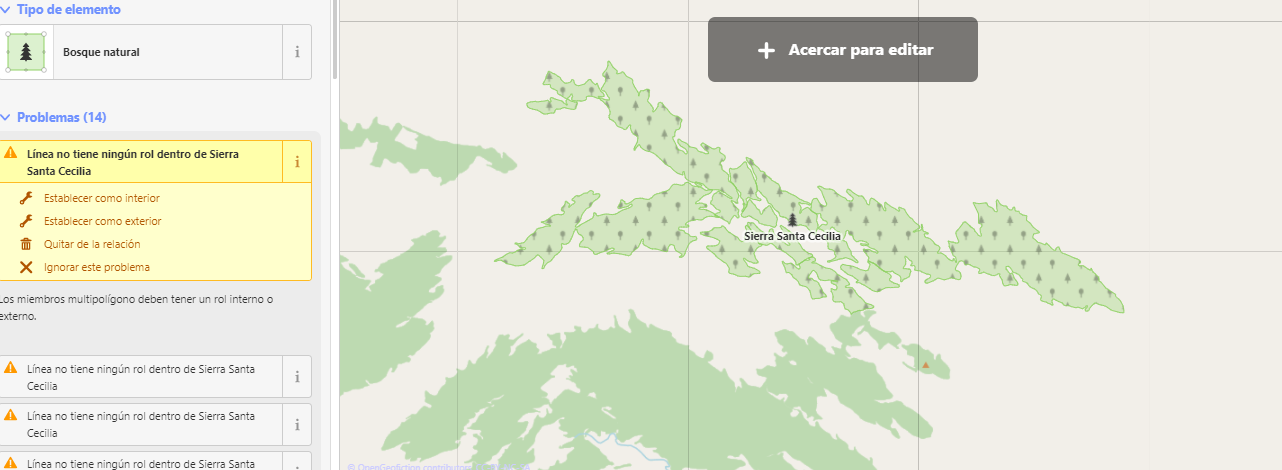 Sometimes it happens that i wait, and it never appear.

I have a question. Not that I want to, but why can’t we create our own territories?
~幼馴染のツンデレ
Posted by Fluffr_Nuttr on 19 September 2021 in English.
Last updated on 23 September 2021.
Greetings!
After the biannual general FSA ballot, Trombonist2003, Cartograp herKing and I have been confirmed by admin as FSA coordinators, with me being focused on the affairs of the Eastern states.
I suspect quite a few of you have heard of a Stanton “partial redo” from Yoyo21’s previous diary on the matter, however today I bring you a more fleshed out plan. Instead of being divided into boroughs, Stanton is a consolidated city-county made up of 11 wards, each with several hundred thousand people and subdivided into many neighborhoods. They are not meant to be claimed individually- anyone can map throughout the city as long as they have permission. But the themes of the wards can give mappers an idea of where to create what they wish. This also gives Stanton a slightly different identity than our NYC.
And with that, here’s the plan.
(Disclaimer- the map and these descriptions are all Infrarrojo’s work. Good stuff though and I’m liberally borrowing from him.)
Hello!
I noticed something a while back, and in my profile, when i look at the map with the home location, it shows the real world and not the ogf world. Anybody else have this issue?]
~Inari-san
I am planning to create a small topo layer area, this autumn or this winter. Currently, the only documentation I’ve found is on the old wiki archive : https://old.opengeofiction.wiki/index.php/OGF:Making_a_topo_layer and the related Talk page.
So I understand that the described method is to draw contour lines, with contour=elevation and ele=N on a separate file, then send it to the admin team.
-
Will there still be this possibility in the future? Is it worth starting ?
-
Is it mandatory to map one curve every X meters (i.e. 10 meters), or not ?
-
Is drawing by hand on JOSM the only method, or did anyone use another method, like heightmap images ? On some countries with topo layer coverage, there are quite a few artifacts that are typical of some computer-generated heightmaps like here: https://opengeofiction.net/#map=12/-20.3116/122.2140&layers=V
-
Quite technical question: If I map i.e. a rectangle on my country, it will create an artifact at the border of the rectangle with all contour lines leading to zero, like there: https://opengeofiction.net/#map=13/-44.9911/146.0147&layers=V If I want to add a topo layer for a new rectangle one year later, how to prevent at best the overlapping problem that it may cause on the join line of the 2 rectangles ? Is it better to keep the 1st rectangle’s OSM file, then add the 2nd rectangle’s topo curves and reimport both ?
Also, when I send to the admin, should I close all the contour lines manually on the side of the rectangle or is it done server-side ?
Best regards, SC.
While I’m editing the map, I receive this error:
The OSM Server “https://opengeofiction.net/api/0.6/” does not know about an object you tried to read, update or delete.
Does anyone receive this error too? Is there any fix?

Hi, I’m a regular user of iD. Yeah, I know, I know, JOSM is the superior editor for most use cases, but I just find very useful the ability to use the web interface and edit wherever I need to without having to go through the process of managing my existing edits. The portability of it all is nice.
Prior to the revamp (a very welcome update, I may add!) the editor was running… well, quickly enough. Now that OGF’s iD editor is now up-to-date with OSM (or at least a far newer version is in place) iD seems to be far laggier than it used to be. I’m getting noticeable, albeit not lengthy, delays whenever I start editing and make my first changes, and the delays get worse the more tiles I load and the more ways/nodes I allow iD to load.
To be clear, it’s definitely not an issue with the OGF site - OSM’s modern iD configuration also gives me these delays to some extent. I was wondering if there was a known way that I can do on my end to make iD less… bloaty, I guess is the best way to describe it? Especially when working in urban areas. I’m avoiding other heavy-resource browser tabs/websites while editing already…
Secondly, re: custom OGF features, I’m aware that the staff-recommended way to allow the OGF map to appear in iD is to use the custom tile field and inputting the OGF tile server. Is the reason for this that the iD will actually “keep up” (a good thing) with new releases of the interface, thusly making any OGF-related customizations (preloaded background maps, customized brand autofilling, etc, etc) to the interface completely unfeasible? Or will iD stay static as it used to do?
~ Kurzov
(P.S. - is the forum up yet or will that take some further time to get up and running?)

Hi, i’m working on the history of some of the cities in my country Pactone, and I’m wondering, are there any tropical cyclones or other natural distaters that commonly happen in the Strait of Lyc, especially in the western half? I want to incorporate some into my country’s history. Thanks, Icefur2
Are there any plans to bring back the scale helper? For me it was a very valuable tool to check my mapping against real world to make sure everything looked right. I’m sure many others will miss it if it doesn’t return.
Thanks

On the old OGF we had directions and a search box. Unfortunately, we don’t have that anymore. Directions didn’t work on the old OGF but search did.
Now that the new server is up, could we possibly get street directions working? It would be a cool addition to see our maps come to life in that form.
Posted by SnowFoliage on 4 September 2021 in English.

Does anybody notice the map once you go to editing is actually a satellite map of the real world? I have just noticed this but I am sure this will be fixed after the beta testing of the improved maps, which by the way is much better already by the style and looks of it.
First thing:
We’re Live! Welcome back, everyone. Happy mapping!
Second thing:
I’ve noticed some of you have discovered that under the new rails port software from OSM, you’re able to change your username.
This is pretty cool, but there’s a problem: our territory assignment system is based on your username. Uh oh.
If you change your username without first letting us know, you might lose your territory. And if you let us know, we might not notice, because we are all very busy right now.
Recommendation: hold off on changing your username. And if if you have changed your username, change it back. For now.
In the long run, we will change our territory assignment system to be based on your user ID number, which is guaranteed to stay the same.
We rebuilt the site (OSM rails port), again, from the bottom up.
Things seem to be working alright.
Thank you to all the OGF community for their patience while we solved this issue. Part of “growing pains” as we get settled in our new home.
Happy mapping!
I am still seeing users being locked out of the site because their email addresses are rejecting our new mail server’s best efforts to deliver email to them.
This is not our fault. Microsoft, Apple, et al. have decided our email server is an untrustworthy email server and are returning our emails to us undelivered. They offer no technical support in how to get un-blacklisted.
Other email providers are not having this problem. Notably, gmail works fine.
If you have a hotmail, icloud, outlook, live .com, or other email provider that might be ignoring our emails, your best solution is to change to a different email address.
To fix the problem, send me an email at luciano(at)geofictician.net , FROM your new email address, and telling me your OGF username and your old email address.
Thanks for understanding.
We are still seeing performance issues with the render server.
To better be able to understand these issues, we have decided to temporarily suspend the ogf-topo render.
Please be reassured - the topo render is very important to me. It’s one of the reasons I’m so involved in this project. I will not leave it “abandoned” as it was on the old OGF server. If I must, I’ll build a second render server to host ogf-topo.
But meanwhile, we will shut down the topo render so that we can troubleshoot performance problems and get the ogf-carto render running at its best possible ability.
Thank you for your patience.
Let’s give this a try.
The rails port seems to be performing okay. So if you want to sign in and try mapping, go ahead and visit the lost password recovery page:
https://opengeofiction.net/user/lost-password
You will get an email with your new password. Reset it and start mapping.
Please note the wiki remains “closed” - you can look at it, but no general editing will be permitted, for at least another week, while we get things organized.
Meanwhile, welcome to our new servers.
Our email server is not yet fully functional for incoming messages, therefore please message using the OGF messaging system or send me an email at luciano(↻)geofictician.net . If I’m swamped with questions, I might take a while to get to yours, however.
Several common problems:
-
A bright red “ActionController…” error. Or else the site keeps logging you out. This is nothing to panic about. It’s a “stale cookie” problem and can be resolved by patient refreshes of your browser cache (control-F5) or maybe trying to open our site in an incognito window. Annoying. How to fix is unclear, so far.
-
Slow load on map render. This will happen for any region where you’re the first visitor. It will pick up speed as more people visit various spots on the map.
-
Oauth seems weird, wrong data, etc. Delete and revoke any old Oauth applications, authorizations and tokens attached to your account, and make new ones. Oauth is working fine, they just need to be generated on the new server rather than inherited from the old one.

This is the first post-transition user diary entry. The Transition Team is continuing to migrate servers and test functionality in the new environment.