 OpenGeofiction

So, I’ve been working on this for a little while now. I still plan on working on Tempora, but for now, my main focus is here. I’ve made Albert as the capital of the nation, with two smaller cities nearby named Evenson and New Peace. The downtown region of the city is composed of the old city and the new region surrounding it. What do you guys think of the city?
Users' Diaries
Recent diary entries
Posted by superleaf1995 on 16 February 2018 in Croatian (Hrvatski).
I guess Kalavsky and Herzevodnia is my country (that i map) and i think, i should continue mapping it? (Yes it is based on Bosnia and Herzagovina with an a language in a combination of Romanian, Croatian and Russian) but the region where i am there is no one who do that, everyone as been colonized in my neighborhood.
Now that i have JOSM i can map more fast.
Can I use the term dagwon for use in Buildtionian Ingerish? Actually the term came from the anime Yuusha Shirei Dagwon (1996 iirc) and the term in the anime means “brave hero” in an alien language; thus this might violate OGF verisimilitude rules. But unfortunately there is a city called Tengah which contains a large portion of real world names (Hatta, Paku Buwono &c; see location in link) so perhaps it is ok to add the term to Buildtionian Ingerish–I would like to rename the Buildtionian National Armed Forces into the Buildtionian National Dagwons, the Army, Navy and Air Force into Land, Naval and Air Dagwons respectively.

Dear all, in this page of the diary, I update you on the last main interventions in the mapping of the territory of Gardensa.
First, in the capital, Giliarca, the San Fortunio Underground Railstation (not a subway station, but an ordinary train station located underground, on the model of several existing underground railway stations, like Penn Station in NY or the recent station of “Porta Susa Sotterranea” in Turin, Italy).
[20180214 Update… Ah: the district surrounding the San Fortunio Station is a financial area where all banks have set up a branch: if you have a bank in your country, choose a nearby building not already tagged, so tag it with your bank and send me a message or a comment below to let me know!]

Secondly, always in Giliarca, the Indaco Amphitheater, on the banks of the homonymous river.
Hi guys I’am sorry but I wasn’t active that much for the last few weeks. I wanted to say that I will map more in Malavsko with a new plan for my country.
Hi everyone
this is a copy of my topic posted on the forum. Sorry for this, but for some reason no one is answering there…
I’m here to ask feedback about the work I’m doing in my first country, Brennland. I’ve started mapping using the in-browser tool, but I’ve switched to JOSM last week. I’ve sketched a part of the main river, Brenne, which flows from the northern part of Brennland towards the big lake in the south. Having very precise ideas about a particular area of the country, I’ve started mapping at a high detail level from a very small city, Freienfeld, in the northern part of Brennland, and its surrounding area (61.8252, 54.6268) This is an area of big mountains and quite wide valleys, an “alpine” scenario, like the ones of the big valleys of Austria or South Tyrol (Italy). I’m asking for a feedback, as this is my first attempt in mapping such complicated areas (and a whole Country). In the recent past I’ve mapped a bigger city, Dominton, in Midistland (38.3351, 93.5067).
Thank you and happy mapping to everyone!
Posted by superleaf1995 on 12 February 2018 in Croatian (Hrvatski).
Things not rendering, ¿What happens???
_of_Sultan_Abd%C3%BClhamid_II_(r._1876-1909)_-_Google_Art_Project.jpg)
Few days ago I had an idea to create a new international organization. The concept of it is rather nonexistent in real world but in certain conditions, for example larger number of monarchies (likre in OGF) it could exist. Here is a draft page for the organization. I would know if more people are interested to join or improve the idea in some way.
If you see your country as a part of the organization feel free to add it retroactively.
There is also discussion on the Forum which maybe you would to see before joining,
Within my country, I have three regions, region 1, region 2, and region 3, I was wondering if someone can help me delete those regions and help me make new ones within my country. I am open to all suggestions and help

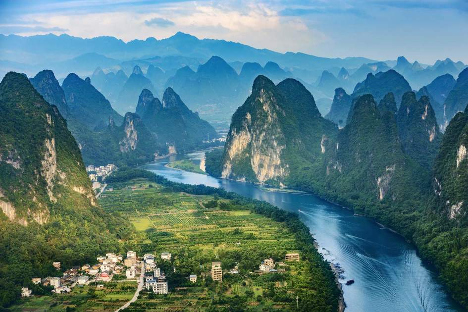
When I was doing initial research to figure out what I wanted Patermas to look like, I spent a lot of time looking at parts of the world located around the same latitude…and I stumbled upon the incredible karst formations in the borderlands of China and Vietnam, along the Gulf of Tonkin. I decided that Patermas needed some epic karst, despite the challenge that mapping such an intricate landmass would present.
Version 1.0 of the Yagui range on the Patermas-Draco border is now live on the map, and I could use some feedback. I get that it’s not quite right yet, so constructive only, please…don’t just say “X doesn’t work,” share an idea or potential solution. :) Or, hey, if you like it the way it is, tell me to chill.
Posted by LemonKing on 5 February 2018 in Finnish (Suomi).
Developping Vinnic Economic Community (VEC) and North-West Ulethan Union (NWUU) seem not to have proceeded as planned. I would very much like to see some progress, therefore I made some suggestions in the wiki. I understand that many territories in Western Uletha are unclaimed and that limits developping the area, but a lot of groundwork could be done as we wait for new members. Please comment:
http://wiki.opengeofiction.net/wiki/index.php/Talk:Vinnic_Economic_Community

Is it allowed to use the Blue countries like a ‘Testing Zone’ for cities to see if we like it, then copy-paste it into our own countries?
Also, could it be possible to ‘Control’ those kinds of areas that we use as a literal ‘testing ground’?
I don’t know if this is supposed to go to forums.
Thanks, Zekiel
Posted by Alessa on 2 February 2018 in Maltese (Malti).

Hello, everyone!
I trust you all had a wonderful beginning to the new year. As you may have (or may not have) noticed, there was no January challenge. The reason is the impetus for this month’s challenge: healthcare.
Quick backstory: at the beginning of the new year, an incident happened through no fault of my own, and I was quite heavily injured. I’m about 75% recovered, and things are getting steadily getting better. The result of the injury took me away from everything for a touch more than two weeks, including OGF. Hence, no January challenge. When I came back, the whole ordeal made me think about how we do healthcare on OGF. Every country is different, and each culture is different. I thought it might be time for a challenge here!
And away we go!
For this month, your challenge is to do something related to healthcare. It could be a hospital, clinic, outpatient practice, pharmacy, surgery center, spa, or even something else. If there is a cultural medicine tradition or a naturalist practice, go ahead and add that! Be creative and have it fit with your country’s culture.
This is a surprisingly hard challenge, however. Remember that not every small town of 3000 people is going to have a hospital. Clinics and urgent-care centers (as they’re called in North America) are often fairly evenly spaced but clustered around population centers. Emergency vehicles need to be able to easily get in and out of many of these facilities too. Consider your traffic flow and where accessible junctions are. Pharmacies are easier to place, but it also depends on how much that country’s government regulates the industry. In other words, placing healthcare facilities means that the community it’s being placed in is relatively planned out already.
How soon will I be able to make my own country, that being the reason joined in the first place.
Posted by superleaf1995 on 30 January 2018 in Komi (Коми).
Why somethimes i can’t access OpenGeoFiction? especially in the morning.
This street seems detailed?
look at the location
Why it stills say Serysia, pöjösttï, etc?
how i can remove that?
My house is haunted
I feel like my house is haunted. I was typing in google “New York” and someone posted “New town on commonia”, i think it was coincidence but i typed “cricket” and someone posted that word of “Cricket on X city”. now i can’t enter google or yahoo, but yes in OGF, also i don’t have proxy or firewall so i think that isn’t a coincidence. Also this have been happened me since January so i like to share this with OGF.
There’s disquiet in Saviso at the moment. The city is due to host the New Ingerish cricket team soon, and they’ve nowhere to play! A city of nearly five million, and the Saviso Cricket Ground is nowhere to be seen! After consulting with cartographers over rum, the St Austellian government realised there’s nobody in Vodeo who can build a stadium, and that foreign expertise should be sought.
I’m quite pleased with how Saviso is coming along, it seems to be keeping up pretty well with its more well-established foreign counterparts. And yet for the life of me, I just can’t build a stadium. I’ve tried to design one myself, but I’m never satisfied with the shape or scale. So I’m turning it over to the community - who thinks they can build a worthy stadium for Saviso? I’m intending on it being something like the the Melbourne Cricket Ground, with plenty of capacity and lots of room for rugby and football in the off-season.
As usual, there’s a crate of Port Adelaide rum in it to sweeten the deal.
I have a few questions in making my country look better.
How do I make exits (off of motorways) appear with numbers? How can I make a trade route to other countries without breaking the rules? How can I make a bridge across a river to another country without breaking the rules?
I am open to all answers and they will be put into consideration.
After the public presentation of Gardensa and its capital Giliarca, some days ago, I received a lot of very interesting considerations by many of you. So: now I’ll I will anticipate the changes that I will bring in the map of my territory in acceptance of these observations.
The main issues were: the position of a big city in the tip of a thin peninsula, with two kind of consequences: human (enemies attacks), and natural (hurricanes and floods), and the unnatural course of the Indaco river, in the center of the peninsula, with a last unjustified turn to the west before the mouth
Well, I must premise that the position of the city in the tip was from the first moment a choiche taken with awareness: it has been one of the reasons behind the choice of this specific territory. And in the discussion in my last post, indeed it has emerged that this fact in itself is not contrary to the principle of likelihood. So, that will not changed.
But, about specific details, most of your critical observations are more than correct: the position of the city of Giliarca needs to be more credible. And so also the course of the Indaco river.
So I tell you now the changes I will bring. Of course you can suggest some “corrections to corrections”.
But please note that what I’m going to write, and the graphs illustrating this, are simplifications: in the actual changes I will modify every detail: roads, railroads, smaller cities etc., and especially taking into account the domino effect, so each change produces others, until it returns to an overall coherence.
I’ve gone in and fixed a lot of problems some people have been stating about my city, Tempora. I’ve improved the airport greatly, but I’m still not entirely sure it’s good yet. I’ve also made the metro system more realistic, but there might still be some problems. I’d like some more advice on how I can improve the city!
I struggled for complete motorways and build some cities.
But time has come.I will work so much for my country again, but my country needs development and knowledge.
Therefore Tedimah will open to the world for trade, alliances, necessary resources, and science.
Firstly, we will request for trade agreements for some countries, secondly, we will have to make some concessions and we are going to submit our offers as well.
Tedimah will join into prosperous countries!