Users' Diaries

Recent diary entries

Posted by superleaf1995 on 12 June 2020 in English.

As more of you know, Uzkesh is not a big deal. In fact, it is empty as a new-acquired territory.

However, recently, i’ve came accross some nice stuff inside my head.

As you can see in the map im linking, it feels not so empty now, and even feels a bit “real” (but not real, real, yet). Here is the map

I’d like to let know that after seeing beregorod and the sorroundings it was quite sad to have lots of empty space. But now, i have a good planning, a nice infrestructure and a path to add details/fixes.

Here is a link to one of the tutorials i followed I was quite scared of redoing the entirity of Uzkesh, since i had a lot of city stuff done. But i had to. So i could make my skills better.

Also thanks to the people who gave feedback.

I’d also like to say as a ex-iD mapper that JOSM helped a LOT, like A LOT in the making of this.

Location: UL27g
Posted by iBallasticwolf2 on 9 June 2020 in English.

I have recently returned to mapping my FSA state of Wilthamshire, and I have made progress mapping the state’s largest locale, New Annshire. However, I have had trouble trying to develop realistic industrial areas. Histor mapped a realistic railway system in my city while I was absent from OGF for several months, which has certainly made it easier, but I still find mapping factories and warehouses a weak point of mine. If you look on the eastern side of my city (https://opengeofiction.net/#map=15/-37.1393/158.2423), you can see industrial areas that I have planned along the train tracks, and I would like feedback and advice on how I can develop these areas realistically.

Another issue I have had is how I can realistically map my city when accounting for hills. I mapped out where the first set of hills on the north side of the river, and on the sides of McMillan Creek are, with green lines in this map (https://i.imgur.com/sjoLVwo.png). Pink circled areas are areas that I want to modify / remap to account for current geography in the area. How can I effectively map these hillsides?

This is a follow up to my previous post.

After reflecting on some of your suggestions and constructive criticism, I’ve redone my topoguide map of AR053. Most changes were made in and around the bay. I made sure that the ancient fault lines were more visible.

Ulihraad Topoguide Map version 2.0 | Enlarge | version 1.0 Ulihraad Topoguide v2

Of course it’s not guaranteed to be the final version. It’s also not guaranteed to be fully representative of how the nation will look on OGF. Obviously it’s going to be a lot more detailed, and some things will change as they’re developed. However, as far as I’m concerned, this is the final version. I shall now proceed with implementing these changes on OGF.

Location: Iqiadna, South Ulihraad, Ulihraad, Neo Delta
Posted by sōTo on 6 June 2020 in English.

Hi Everybody,

My name is sōTo and i have recently became a new user.

I have been mapping over a few days and i made this city. It is a rest stop type of city based off on tourists driving on the highway. Please feel free to give me suggestions on how to make my mapping style better.

Also, when I tried downloading JOSM, (im on mac btw) when I would try and open the application, it kept giving me this error: “JOSM” cannot be opened because the developer cannot be verified. Does anyone have any advice on fixing this issue?

Thanks,

sōTo

Location: Soate Rest Stop Retail Area, Soate, Kalabag County, Sutarasa, Gobrassanya
Posted by geoboi on 4 June 2020 in English. Last updated on 5 June 2020.

Hey everyone,

Hope you are all staying safe. I just wanted to give everyone an update on my work in Eastern Uletha. I am currently working on an overhaul of the Semanish language, as well as planning out my capital city, since I have my mountains and rivers planned out already. The capital city started out as a trading village, but slowly grew into a city due to its isolated and strategic location on a peninsula jutting into a large lake. I’m mainly concerned about the scale of the whole project, so let me know if there’s anything I need to fix.

the plan

Location: Puląbat, Semanya

As the new owner of AR053, one of the first things I had to do was rework the topography of the area. I didn’t like the previous topography since it didn’t fit my idea for the country, and I felt it wasn’t the most realistic. So I took the topographic map the previous owner had made for the whole southern Astrasia, and built on top of it.

Since the northern nation is not currently being mapped by anyone, and the owner of the southern one hasn’t been active in a while, it’s not like I could coordinate with neighbouring mappers to rework the topography. Besides, I wouldn’t want to impose my ideal topography on neighbouring mappers, especially when their areas are so developed already.

Thus, I pretty much kept the topography as it was around the borders, while also making sure it matched the topography of the rest of the area, of course.

I’m posting this mainly for any current and/or future neighbours, as well as admins so that they know why I’m doing what I’m doing lol. Anyway, here it is.

… See full entry

Location: Puridub, Striteg, North Ulihraad, Ulihraad, Neo Delta

Hello mappers,

Welcome to the movie world of Cinasia, I have roughly finished this weekend, a town for the Cinasia’s movie industry, one studio complex and and one movie related theme park which is like the Universal Studio. Is there anything I should add?

Location: 聯合影視中心 United Studios, 四邑省 Sze Yup Province, Cinasia

Hey everyone!

I am opening a part of my territory where everyone is free to add stuff! This is for a couple of reasons: 1. I’m feeling generous, and need inspiration for some of my own work. 2. I have noticed that a lot of free mapping areas are becoming quite full, with not much freedom to add stuff.

Before you go and start adding stuff, I want to enforce some conditions. Don’t worry, most of them wont restrict you too much!

  1. DO NOT edit outside the island. If found doing so, all work will be removed. It is possible that editing outside of the allotted area will result in a temporary ban from admin.
  2. Try and keep the style of mapping rural. There will be one large city, which is the only one. I will decide where it lies.
  3. Try and keep most mapping close to the coast, as seen with most islands. There can be some roads that go through the mountains of the island.
  4. Most of the city/town/village names will be a mix of Thai and Vietnamese. So try and keep your names like these! You can use my city names as a reference.

Let me know if you have questions! Here is where you can get started! I’m excited to see what you come up with!

Best wishes and happy mapping,

forky

Location: Batis, AR004a
Posted by Mapping Expert on 28 May 2020 in English.

Hi again to the whole community.

It is a great pleasure to speak with you again. As everyone surely knows, more than 1 month ago I launched the first “Mapping challenge”, which proposed to users to start developing natural mapping, to start developing our mapping in a realistic and orderly manner. Because we must continue the challenge, I plan to set the limit on June 2, 2020. Please add your natural mapping examples below and a contest will be held to determine the “Best mapping of the challenge”.

After having completed the previous challenge, I am thinking of developing a new one (whose theme I have not yet defined), for which, on this occasion, I ask you to reach a consensus for one:

  1. Large-scale mapping of cities (urban streets, main roads, important buildings, urban parks).
  2. Mapping of the railway, transport (land, sea and air) system, in addition to the terminals.
  3. High-detail mapping of buildings with a 3D effect.

Please fill out this form: Google Form and provide your natural mapping examples please.

Happy mapping - Mapping Expert

Posted by Dimitrij on 27 May 2020 in English.

Hello, I have started mapping an island nation recently and since I haven’t done coastline mapping much before, I am not sure how to do it. I am pretty sure what I did was right but it still hasn’t shown up after more than 12 hours since I made the edits to the coastline. I am not sure if this is normal, so I would like someone better than me to look at the coastline and see what is wrong with it. (https://opengeofiction.net/#map=15/10.8909/37.2957), that is the link to the island I edited and as you can see in view, it looks horrible but in edit, you can see my coastline changes and they only show in edit. Whoever knows what is wrong please help.

Posted by Hilsonbergman on 24 May 2020 in English.

Hi mappers,

Today is my last day of quarantine, everything goes fine, I can back to work tomorrow.

I map a lot during the 14 days and now may I present my tropical atoll Ching Sha.

It is a natural reserve, no permanent residents, but there are Marines, scientist and fishermen come for shelter. Permit is required for ecotourism. The idea comes from Pratas Islands .

Location: 21.381, 156.491

In townmaps (may be not only in Europe?) it is usual, to show the terminal of a streetcar-line with the line number encircled - like ⑤. This encircled numbers are defined in the Unicode as hexa from #2461 and following or decimal from 9312 and following. In the Unicode-list there are the encircled numbers 1 to 20. Also there are some encircled letters, if your lines are lettered.

In the ID-editor it is not possible, to give this encircled numbers into the name-tag directly only with the ALT-key-methode. So you please must look in an unicode-list and copy this character and paste it in the name-tag of your tram_stop-tag.

This encircled number logical looks smaller as the normal number. If you will be able to read this encircled number on the map, the character has to be in a greater grade. For this please add to your tag “railway=tram_stop” the tag “service=terminal”. Then the name of the tram-stop will appear in the histor-style in a greater grade as usual, so that the encircled number good is readable. In the standard-style this service tag will do nothing, there the tag is neutral. Visible in the histor-style this terminal-tags are in zoom 15; the normal name-tag of tram-stops in zoom 16.

Exemple for a streetcar-system with such terminals may be Aerwinya in Oakhill, Federal States - see [https://opengeofiction.net/#map=17/-37.80576/161.02969&layers=H]

Thanks to ChalieG for help.

Posted by realTomHolland on 22 May 2020 in English.

Hi! Im a fairly new user. I have already acquired my first country, Margüela.

I would like for someone to take a look at my first two cities (Catalina and Tarifa) and give a commentary or tips on how to map on them.

I would also like to ask if there is a way to know who made specific countries, because I want to contact several people around the gulf my country is located in.

Another thing I have in mind is if there is any way to make the editing map any bigger, since it only lets you edit at around -400m scale. This would be to build highways.

Thanks for any feedback! -Tom

Posted by Litvania on 12 May 2020 in English.

I’ve been trying to work more on Litvania’s map.

This involved a changeset uploaded on Monday, which uploaded, and refused to show up on the map after a day. I know this is normal, I’m not a beginner. But, then I looked in JOSM if it had even saved as an actual changeset (keep in mind I had the “Upload Succesful!” message). It didn’t, and now I have to restart.

Frustrations aside, anybody had this problem before or maybe know what I did wrong?

Location: Alenov, Modrá Hora, Historická země Dolsko, UL15b
Posted by Friedrich Kirchen on 12 May 2020 in English.

It’s been a while!

My work took a lot of time from me, and Welstand-Westrijk was kind of abandoned.

But our friend Covid came! And Spain is going through a hard lockdown.

One of the news during this time was that Olympic Games in Tokyo were cancelled, and I remembered that Kirchenburg were at the gates of hosting the Geolympiad 2020. So I came back to mapping.

I’m back to the mapping in Kirchenburg, and the time gave me some perspective on what I like and what i hate. Wanted to reshape the Olympic venues, but as far as I know, the Geolympiac was never officially goven to Kirchenburg, and it look quite well.

I’m reshaping the city. Worked on Grauberg area, in close town Gëlteen, and in a theme park.

I’ve seen really interesting new mapping around OGF. Nice to see everything keeps alive.

Hope everything goes well!

Hey everyone!

What is the reason for changsets no loading? I’ve heard this from other diary entries and I was wondering if a program that renders the changset onto the OGF map is not working properly or is slow. Is that the reason? I’m just curious.

Happy mapping, Geo

Location: Ferdinand-del-Catán, Catán, Ville de Catán, Ataguriay-Marujuan, Grand-Sud, Nayinie

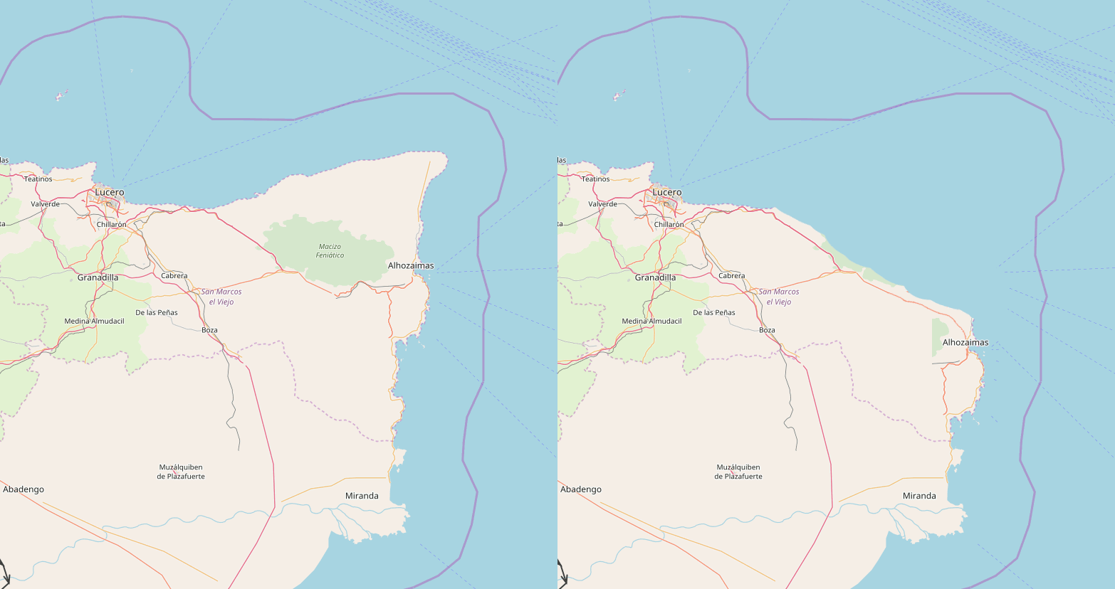
Hello!

Before I moved from Commonia to my current territory, I used to name my territory “San Marcos”. When I arrived to Antarephia, I decided to continue to name my country “San Marcos”, and I placed my old mapping in the north making a region with the name of “Old San Marcos”.

This region has always theoretically been composed by 4 (5?) provinces:

  • Lucero (capital)
  • Granadilla
  • Castillejo y Ebre
  • Alhozaimas
  • Jaca (?)

Even if I tried to think about how to make it fit with the area, I wasn’t able to. So I’ve had this idea to fix it:

… See full entry

Location: -26.793, 47.541
Posted by rickypro on 6 May 2020 in English.

While I am doing Diary entries, I may as well ask if it is possible to edit the wiki, or add pages such as my country? I haven’t figured out a way to do this as yet. I understand if there is a no edit rule to prevent vandalism, but maybe there could be a way to limit what pages a user could edit to their own because I would love to add my country and cities on the wiki.