Users' Diaries

Recent diary entries

Posted by wangi on 5 July 2020 in English.

Hi, what was formerly Commonia has been divided into a few territories to try and get some language consistency. This is ahead of a dedicated English language blue territory as part of the Federal States.

The territory map has been updated. Click on the blue territories to see the theme and language. But the translations were largely on automatic translate results…

So, please check that map, if you know the languages and the icons are wrong - let us know here!

Posted by geoboi on 4 July 2020 in English.

Hello everyone!

I hope you are all doing well. I’ve been planning and re-planning my Ulethan country a lot during this quarantine, but I think I’ve finally found a plan that can stick and serve as a launchpad for the final plan of this nation. I was inspired by this image to plan out my country’s topography, since it plays a significant role in the development of cities, the course of rivers, and a bunch of other things. So, I got to work. I will be the first to admit that I am not the most skilled digital artist, so the sketch I have provided is something I am quite proud of.
Topo Map The light blue close to the lakes signifies a “sea level” elevation, the adjacent color references 0-100 m in height, the color next to THAT references 100-500m, and every color afterward references its own set of 500m-elevation intervals.
Here is the legend (it’s too big to display on this diary entry so I just linked it lol).

… See full entry

Location: Lehvą, Semanya
Posted by CharlieG on 3 July 2020 in English.

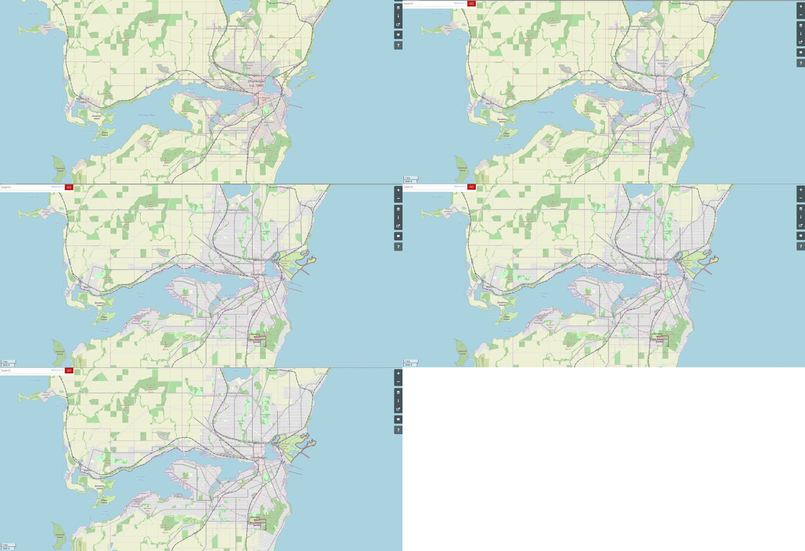
Hi everyone, I don’t know if you’ve seen Luciano’s great diary entry about his exposition in Ohunkagan, an evolving/historic city in Makaska, FSA, but I mentioned in the comments that I’ve figured out how to edit the way OGF looks to represent a Dark Mode. here’s the image of Ohunkagan using this dark mode. It’s a very wild idea as it acts like a new layer (like histor’s but dark) but it’s easy to set up and try on your own computer.

Before I tell you how to do this, here are some examples of what I mean by Dark Mode. Dark Mode is a reference to the way OGF and other sites look when the normal white background of websites are turned to black. A lot of the time, this can help at night when we don’t want to look at bright screens, or with people who see white text better than black text. I say white text because, to accommodate the black background, everything else is either color-flipped or altered to look lighter and create better contrast. I’ve talked to OGF members and other friends about whether if this is helpful or disgusting to look at–most say disgusting–but I think it’s an interesting sight. Anyway, here’s some photos:

5 pics of standard layer dark mode 5 pics of Ohunkagan in topomap dark mode 5 pics of Ohunkagan in histor layer dark mode

In my opinion, these photos look incredible, especially in TopoMap dark mode. Now, here’s how to do it yourself. Firstly, get Google Chrome browser. Secondly, press the three dots in the top-right corner, hover over More Tools, and click on Extensions. Once in Extensions, click on the three bars in the top-left corner and then Open Chrome Web Store. Once there, search up ‘Dark Reader’ and add it to Chrome. There might be more configuration to do, but this extension will turn virtually any website into Dark Mode through CSS, HSL, and Dynamic color inversion. In other words, this will turn OGF dark for free!

… See full entry

Location: Gunboat, Ohunkagan, Quincey Township, Swift Parish, Makaska, Federal States of Archanta

As part of my historical mapping of Makaska, I have been working on the Ohunkagan 1895 Exposition & World’s Fair. The concept is somewhat modeled on Chicago 1893 or St Louis 1904. Think of it as a turn-of-the-last-century temporary theme park.

The Exposition grounds are mapped on the shores of “Lake Great and Unnamed” (and when will we ever name it?), east of downtown Ohunkagan. The city raced to complete the beginnings of its new elevated electric train network in time for the fair, with two stations accommodating visitors and directly linking to downtown. The grounds also feature a temporary train terminal where VIPs and special excursions from around the FSA can park their charter trains, and an intramural ferry and streetcar for getting around the park.

Here is a map link: https://opengeofiction.net/relation/175412

I have two things for the OGF community.

First - feedback? What’s missing? What do you recommend? Remember this is for the year 1895. The theme is “developing our frontier” and features lots of exhibits on industry, resource extraction (with a focus on Makaska’s primary industries: coal, lumber, wheat, buffalo/cattle, iron ore). What would you like to see me add?

Second - if you own or coordinate a state or country (which is most of us!), which existed in 1895 (maybe not everybody!), then you need an exhibit at the Exposition. The FSA “state exhibits” are in the red circle area in the screenshot below. The international “country exhibits” are in the yellow circle area. You may take over an existing building labelled as “State Exhibit” or “Country Exhibit”, or you may create a new one in an empty spot in those circled areas. No permission needed, just do it. I’m trusting you all to behave yourselves, and I don’t want to be swamped with messages. Worst case, I’ll delete your edits as inappropriate.

… See full entry

Location: Peery, Ohunkagan, Rollingstone Township, Swift Parish, Makaska, Federal States of Archanta
Posted by IAmDaCraziestBoi on 2 July 2020 in English.

My new focus is shifted to Lindenville in Rhododactylia, I made sure there wasn’t a certain culture we had to follow because I saw Asian themed the last area, I also wanted to make sure this was a editable territory to everyone, as I don’t own territories or wish to own one (at least for now). I have a feeling I am doing too many cities since I work on one and abandon the rest, so it would be great if anyone can add to those, and Lindenville.

Lindenville

I am going to do the main roads and highways prior to working on residential areas and roads, and buildings. I also started adding more suburbs as motorways are becoming developed in the area. It would be appreciated if you do help develop the suburbs and/or the city. I am going from motorways to tertiary roads before starting significant development of residential roads, same applies to the suburbs. I am also planning an airport in Lindenville, location will be determined.

Location: Linden, Meredy, Rhododactylia
Posted by 2amCereal on 30 June 2020 in English.

I’m starting to develop the main port facilities for my country that will deal with international cargo and I’m wondering whether to add shipping routes to other countries.

As I’m sure you’re aware, OGF has an abundance of shipping/ferry routes (way more than OSM does). Are the lines between countries supposed to be for passenger ferries, like in OSM, or for both passenger and cargo? Because if they are exclusively passenger then I’m not sure why there are so many intercontinental ferry routes. My country is a small island nation so it would not have many long ferry routes, especially seeing as there is an airport instead.

I will continue to develop this area and city, and eventually its suburbs.

One of the biggest projects I ever started is the Great Commonia Highway, if you feel a section of this is impacting your area you can modify the path where it is impacting your project(s).

I am planning to start Garsenon area once Pipe Bay area is done. I am planning to make two malls throughout Pipe County, one in Pipe Bay and the other in suburb Pimall. I have recently turned New Commons Freeway from a trunk road to a motorway as I agreed that a motorway would fit for myself. The route is from Pipe Bay southeast to northern Port Blanton.

Pipe Bay

I am focusing on the city before its suburbs. This is one of two locations in the urban area where a mall will exist in, the other, again, is Pimall, a suburb of Pipe Bay. I will look for an area within the city limits that is large enough to work on my mall and supposedly surround the mall with residential areas and etc. Carlisle and Pesobrook are both suburbs of Pipe Bay, especially true for Carlisle in Duvar. Another suburb along with Yolkerville will be placed in neighhboring Minn-am-Gabots.

Garsenon

When I begin my focus here, in weeks to months, there will be 8-12 suburbs in 2 counties, with 2 of them in both counties.

Magonia

It may take months for heavy focus and rapid development to occur in this area from just me, however it is recommended that you guys do add to it so I wouldn’t need to do much work to it after all.

Location: Pimall, Pipe County, துவரன் Tuvaran, AR922

Hi again!

I have already finished the construction of Gobras Sky Mall and started making the Sky Point Concert Hall in this plot.

I will then continue to develop all the empty plots north of Sky Point, as well as extending the Sky Point monorail to encompass all or most of these new developments.

If you have any ideas for the empty plots let me know, so I can build them.

So long!

Hello if you’re reading this!

I’m still getting the grasp of this diary system, I don’t post much in here lol

So then…

I acquired my country, Former Unionist Colony of Bromley in early spring (?) and I wanted an island territory, however they were in demand so I decided to settle for a mainland territory.

The problem is, the country that I got was already mapped in by an inactive user. Therefore, there was a lot of mapping which I did not like:

-The names of the places -The road references -The town layouts -The drastic change between European styled and American styled towns -The landscape

I’ve been on a mission since this time to paint this country in the way that I want it, with it being inspired by a British layout.

Bromley City, the capital, has been a massive challenge. The city is on a peninsula so it’s quite awkward to draw but I prefer it in this place. The only thing I do not like is the road layout that was used. The layout is not creative AT ALL and is just blocks identical to each other. I didn’t mind it at first but now I’m working hard to redraw the entire city.

So why this entry? I’m looking for suggestions for my city, have a look at it (I’ll link it below) and let me know before I draw over it so I have no space to draw important buildings.

I’m wondering whether to widen the city because I think it might actually be too small.

I will also link the wiki article to my country so you can get some context.

Thank you!!!

Location: Southwold, Chestham, Erbale, Bromley
Posted by mstr on 19 June 2020 in English.

After one and a half centuries of growth and prosperity the Great Eastern and Stanton Folkstone Railway headquartered in Stanton (Central Av.) had to declare bankruptcy this week.

Especially its very poor track conditions caused many extremely costly derailments. error To make matters worse several hundred kilometers of rails have been stolen during operation.

… See full entry

Location: Thompson Bridge, Holliman County, Michisaukee, Federal States of Archanta

Hello there.

It has been a year and a half since the last challenge. I’m glad to announce the reinstatement of the Mappers’ Monthly Challenge. First off, I will like to thank Alessa and Luciano for letting me continue this series of challenges.

As of now, new challenges will be launched on every 15th of the month, but this may be subjected to change depending on my schedule. I will continue running the series for the time being.

As with past challenges, the challenges are not strictly obligatory. It is strongly recommended to use JOSM as your default mapping tool when attempting the challenges. Post what you have in the comments below; do not be afraid to provide feedback on submissions also.

This is a great place to learn and have fun. It is my hope that we get a chance to see all the good things that users are doing around OGF and new creative features on the map.

Alright, let’s jump into the challenge:

Mappers’ Challenge #29: All aboard the bus!

In OGF, I feel that we have, as a whole, neglected buses in favour of other modes of transportation like subways, rails and trams. Buses are often seen as outdated and less stylish than other rail transport. Besides just putting bus stops as decorations and having a few bus stations scattered around the city, it is a bit difficult to visualise bus routes on the map.

Actually, on the contrary, there is a public transport viewer to visibly see bus routes, such as this one in Gobras City. You can check the various bus routes and see how they are tagged on the map. To create bus route relations, you need to use transport route relations in JOSM.

So for this challenge, develop a basic bus network with the necessary infrastructure for your town/city. You can start a town from scratch and develop it, or use an existing town or city requiring a bus network.

… See full entry

Posted by superleaf1995 on 12 June 2020 in English.

As more of you know, Uzkesh is not a big deal. In fact, it is empty as a new-acquired territory.

However, recently, i’ve came accross some nice stuff inside my head.

As you can see in the map im linking, it feels not so empty now, and even feels a bit “real” (but not real, real, yet). Here is the map

I’d like to let know that after seeing beregorod and the sorroundings it was quite sad to have lots of empty space. But now, i have a good planning, a nice infrestructure and a path to add details/fixes.

Here is a link to one of the tutorials i followed I was quite scared of redoing the entirity of Uzkesh, since i had a lot of city stuff done. But i had to. So i could make my skills better.

Also thanks to the people who gave feedback.

I’d also like to say as a ex-iD mapper that JOSM helped a LOT, like A LOT in the making of this.

Location: UL27g
Posted by iBallasticwolf2 on 9 June 2020 in English.

I have recently returned to mapping my FSA state of Wilthamshire, and I have made progress mapping the state’s largest locale, New Annshire. However, I have had trouble trying to develop realistic industrial areas. Histor mapped a realistic railway system in my city while I was absent from OGF for several months, which has certainly made it easier, but I still find mapping factories and warehouses a weak point of mine. If you look on the eastern side of my city (https://opengeofiction.net/#map=15/-37.1393/158.2423), you can see industrial areas that I have planned along the train tracks, and I would like feedback and advice on how I can develop these areas realistically.

Another issue I have had is how I can realistically map my city when accounting for hills. I mapped out where the first set of hills on the north side of the river, and on the sides of McMillan Creek are, with green lines in this map (https://i.imgur.com/sjoLVwo.png). Pink circled areas are areas that I want to modify / remap to account for current geography in the area. How can I effectively map these hillsides?

This is a follow up to my previous post.

After reflecting on some of your suggestions and constructive criticism, I’ve redone my topoguide map of AR053. Most changes were made in and around the bay. I made sure that the ancient fault lines were more visible.

Ulihraad Topoguide Map version 2.0 | Enlarge | version 1.0 Ulihraad Topoguide v2

Of course it’s not guaranteed to be the final version. It’s also not guaranteed to be fully representative of how the nation will look on OGF. Obviously it’s going to be a lot more detailed, and some things will change as they’re developed. However, as far as I’m concerned, this is the final version. I shall now proceed with implementing these changes on OGF.

Location: Iqiadna, South Ulihraad, Ulihraad, Neo Delta
Posted by sōTo on 6 June 2020 in English.

Hi Everybody,

My name is sōTo and i have recently became a new user.

I have been mapping over a few days and i made this city. It is a rest stop type of city based off on tourists driving on the highway. Please feel free to give me suggestions on how to make my mapping style better.

Also, when I tried downloading JOSM, (im on mac btw) when I would try and open the application, it kept giving me this error: “JOSM” cannot be opened because the developer cannot be verified. Does anyone have any advice on fixing this issue?

Thanks,

sōTo

Location: Soate Rest Stop Retail Area, Soate, Kalabag County, Sutarasa, Gobrassanya
Posted by geoboi on 4 June 2020 in English. Last updated on 5 June 2020.

Hey everyone,

Hope you are all staying safe. I just wanted to give everyone an update on my work in Eastern Uletha. I am currently working on an overhaul of the Semanish language, as well as planning out my capital city, since I have my mountains and rivers planned out already. The capital city started out as a trading village, but slowly grew into a city due to its isolated and strategic location on a peninsula jutting into a large lake. I’m mainly concerned about the scale of the whole project, so let me know if there’s anything I need to fix.

the plan

Location: Puląbat, Semanya

As the new owner of AR053, one of the first things I had to do was rework the topography of the area. I didn’t like the previous topography since it didn’t fit my idea for the country, and I felt it wasn’t the most realistic. So I took the topographic map the previous owner had made for the whole southern Astrasia, and built on top of it.

Since the northern nation is not currently being mapped by anyone, and the owner of the southern one hasn’t been active in a while, it’s not like I could coordinate with neighbouring mappers to rework the topography. Besides, I wouldn’t want to impose my ideal topography on neighbouring mappers, especially when their areas are so developed already.

Thus, I pretty much kept the topography as it was around the borders, while also making sure it matched the topography of the rest of the area, of course.

I’m posting this mainly for any current and/or future neighbours, as well as admins so that they know why I’m doing what I’m doing lol. Anyway, here it is.

… See full entry

Location: Puridub, Striteg, North Ulihraad, Ulihraad, Neo Delta

Hello mappers,

Welcome to the movie world of Cinasia, I have roughly finished this weekend, a town for the Cinasia’s movie industry, one studio complex and and one movie related theme park which is like the Universal Studio. Is there anything I should add?

Location: 聯合影視中心 United Studios, 四邑省 Sze Yup Province, Cinasia